Santa Paula Airport, SZP
Rich is available for training here sporadically during the winter months

SANTA PAULA, CA
75 miles NW of LAX; 45 miles ESE of Santa Barbara, CA; 15 miles East of Ventura, CA
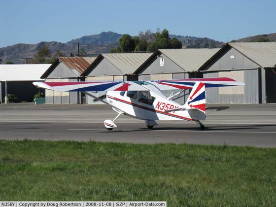
ANTIQUE AIRPLANE CAPITOL OF THE WORLD!
Do you enjoy kickin’ tires at small airports? Then you’ll love strolling along Santa Paula’s ramp…
View the airport’s Live Web Cam
Airport Happenings
First Sunday of the Month
Airport open house — Antique and other airplanes on static display. SZP is a living, working museum! Docents on hand for walking tours. Car/motorcycle clubs sometimes join in. 10:00 a.m.-3:00 p.m. WX permitting. FMI, see SZP Museum.How to Get Here
By Commercial Airline — Check for flights into LAX, Burbank, Santa Barbara, & Oxnard Airports.By Car From LAX (about 1:30) — Take the 405 Freeway (Santa Monica Freeway) Northbound, to the 101 Freeway (Ventura Freeway) North/Westbound, to the 126 Freeway (Santa Paula Freeway) Eastbound. Exit the 126 Freeway at Palm Avenue. Turn right at the stop sign, then left onto Santa Maria Street. Follow Santa Maria Street to the parking lot.
By Car From Burbank (about 1:00) — Take the 210 Freeway Westbound, to the 5 Freeway Northbound, to the 126 Freeway (Ventura Freeway) Westbound. Exit the 126 Freeway at Palm Avenue. Turn left at the stop sign, then left onto Santa Maria Street. Follow Santa Maria Street to the parking lot.
By Car From Santa Barbara (about 0:50) — Take the 101 Freeway Southbound, to the 126 Freeway (Santa Paula Freeway) Eastbound. Exit the 126 Freeway at Palm Avenue. Turn right at the stop sign, then left onto Santa Maria Street. Follow Santa Maria Street to the parking lot.
By Small Airplane — see the Pilot’s Guide below as well as the NOTAM about the aerobatic area East of SZP.
Check TFR’s and other airspace issues
Local Accommodations
Santa Paula Inn (bed & breakfast, four blocks north of the airport) — 805-933-0011
Glen Tavern Inn (historical landmark, two blocks east & four blocks north of the airport) —
805-933-5550
Ventura, CA (our coast town, about 10 miles west)
Logsdon’s Restaurant (large copper-roofed building on the north side of the airport) — 805-525-1101
SZP Pilot’s Guide
For information only, not for navigational or cross country planning purposes.
View the airport traffic pattern diagrams
- CTAF: 122.9 (unmonitored)
- Runway 04/22 — 2,650 feet x 60 feet (paved, unlighted)
- RWY 22 — Left Traffic (2,420 feet after displaced threshold)
- RWY 04 — Right Traffic (2,476 feet after displaced threshold)
- Navaids:
- Airport Coordinates — 34 20′ 50″ N, 119 03′ 37″ W
VOR Freq Rad DME ---------------------------- GMN 116.1 184 29.1 FIM 112.5 251 8.9 CMA 115.8 357 8.2 RZS 114.9 092 36.5- Field Elevation: 245 feet MSL
- Traffic Pattern Altitude: 850 feet MSL (600 feet AGL)
- Phone Numbers:
- Airport Office — 805.933.1155
- Weather — 1.800.WX-BRIEF
- Services:
- Fuel — Chevron, self-service, 100LL Only
- Food — Airport restaurant; restaurants in town
- Lodging — in town
- Car Rental — in town
- Operational DON’Ts:
- Do not make straight-in approaches
- Do not make 45 degree entries onto the downwind leg
- Do not make overhead approaches
- Avoid touch & go’s on weekends or holidays if the airport is particularly busy
- Do not land or takeoff at night
- Helicopters — Do not land without prior written permission
- Helicopters — Do not cross over the runway under any circumstances
- Operational DO’s:
- Do check the windsocks and tetrahedron for wind direction
- Do fly upwind over the city at 1,500 feet MSL quietly
- Do enter crosswind 1-1/2 miles from the departure end of the active runway
- Do enter downwind at pattern altitude (850 feet MSL)
- Do be vigilant for other traffic — non-radio airplanes are often in the pattern
- Helicopters — Do arrive & depart the helipad to the south only
- Do make accurate position reports (on 122.9)
- Do be a good neighbor
- Do enjoy the airport!
NOTAM – Active Aerobatic Training Area East of SZP
What is the extent of the aerobatic area?
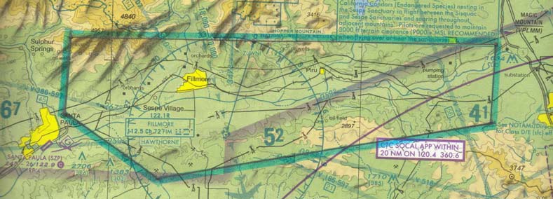
The waivered aerobatic area is outlined on the map below, but essentially the area overlays the valley between the town of Santa Paula and the I-5 Freeway at Magic Mountain, from the foothills to the North to the foothills to the South. For exact coordinates, see the Special Notices section of a current Airport/Facilities Directory (AFD).When is the aerobatic area active?
The aerobatic area is likely to be active from sunrise to sunset whenever the weather is VFR (which here in SoCal is most of the time).What are the altitudes specified in the waiver?
Waivered aerobatic activity is confined to the block of altitude beginning at 1500 feet AGL up to 5500 feet MSL.Can anyone use the aerobatic area?
Yes and no: anyone can fly in and through the waivered area; however, ONLY THOSE PILOTS AND AIRPLANES specifically authorized by, and adhering to the provisions of, a waiver issued by the Van Nuys FSDO can perform aerobatics legally in the valley East of Santa Paula. Any pilot performing aerobatics in the valley East of Santa Paula who is not attached to a current waiver would be in violation of FAR 91.303(d), among others.How can I tell if the aerobatic area is active?
1. If it’s day VFR, assume aerobatic flight is in progress in the waivered area.
2. Contact Point Mugu Approach on 124.7 and ask if the area is active.
3.Pilots in aircraft with radios are encouraged to monitor 122.775 when transitioning through the valley. Simply transmit in the blind, “Santa Paula Aerobatic Area, is anyone out here today?” or something similar.How can I minimize the risk of a close encounter with an aerobatic airplane in the area?
1. Look outside!
2. Assume the area is active at all times.
3. Avoid flying straight down the center of the valley at 3,000 feet MSL — most of the aerobatic activity occurs between 2,000 and 4,500 feet MSL between Santa Paula and Fillmore, though aerobatic pilots from Van Nuys typically fly over the Magic Mountain/Newhall area. Local aerobatic pilots also tend to divide the practice area into two parts: North of the 126 Freeway and South of the 126 Freeway.All things being equal and whenever conditions make it safe to do so, the best plan would be to fly right over the top of the freeway or along the foothills on either side of the valley.
How many aerobatic airplanes might be in the waivered area at any one time?
Particularly during the weekends in the summer months, it’s possible for the area to have as many as three or four airplanes performing aerobatics pursuant to a waiver at the same time! Again, keep your head on a swivel and monitor 122.775 if you can.
Monitor 122.775 in the aerobatic area
(refer to the current Los Angeles VFR Terminal Area Chart)

Other Airport Businesses & Local Things to Do
Tell them Rich sent you!
- SZP Museum
- Dedicated to educating the public about aviation in general and Santa Paula in particular.
- Aviation Legends
- Great-looking aviation calendars by local pilot/photographer Michael Terry.
- CP Aviation
- Primary through Advanced flight training and airplane maintenance under one roof.
- Ray’s Aviation
- Aircraft maintenance and avionics shop, specializing in aerobatic and fabric aircraft. Fast, efficient, clean service!
Visit the Santa Paula Murals
A walking tour of nine murals that tell the story of Santa Paula. Two of the murals were created by Santa Paula Airport’s own Wendell Dowling and feature aviation an other transportation themes.

